Please Send Me Your Track Logs

Go ahead...Let it out.

Moderator: hemingray

User avatar
GrizzlyGuy
Forever On The trail - RIP
Posts: 1411
Joined: Sun Jul 08, 2007 6:11 pm
Location: Truckee, CA
Contact:

Please Send Me Your Track Logs

Postby GrizzlyGuy » Fri Jun 25, 2010 9:19 am

I'm trying to compile the world's greatest ATV trail map(s) of the Sierra region and make it available to anyone who wants them for free. Whenever possible I use actual ride tracks to create the map(s), so it ends up being spot-on accurate. If you guys have any track logs that you'd like to donate to my project, please E-mail them to me. My address is GrizzlyGuy at AdventureWorld dot TV. Any format is fine, I can usually convert it as needed.

The maps I create can be loaded into Garmin GPS's so that the trail lines (color-coded for type and difficulty) are visible on your display, floating above whatever topo maps you choose to load. Or, they are visible by themselves if you don't load topos into your GPS. I'm trying to figure out a good way to turn them into color PDF files as well so you'd be able to print them out. I can also make the source file available to anyone who knows how to load them into other GPS types or wants to modify what I have.

EigerMike sent over some of his High Lakes area tracks so we're on our way to mapping out every trail in that area. This is super-cool for me since I've never ridden in that area and I get lost real easy. :D

Here is an example of what the trail/road lines look like in the Bear Valley OHV area:

Image

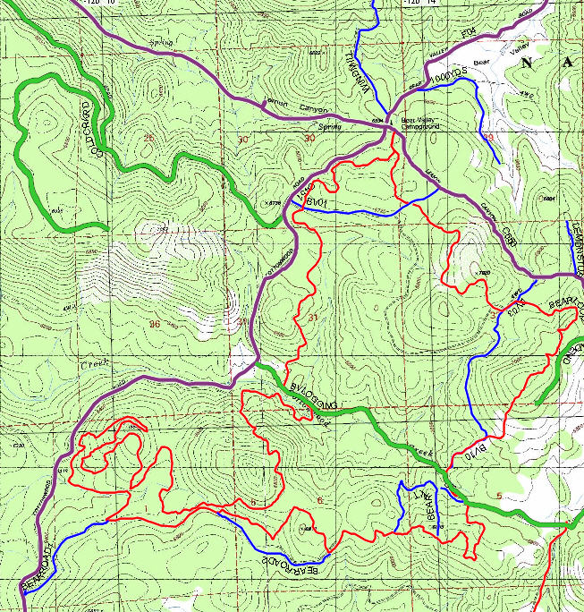
The red line is the actual loop trail, while the other lines are the dirt roads in that area. The background topo would get replaced with whatever you load into your GPS. I also have a fairly massive waypoint file that contains trail/road junctions, trailheads and interesting points that you can select from and load (or not).

Thanks in advance for spamming me with track logs!
TV For Thrill Seekers: http://AdventureWorld.TV
More Videos: http://GrizzlyGuy.TV
Some More Videos: http://www.youtube.com/user/ATVGrizzlyGuy
Photos: http://www.GrizzlyGuy.com/ATVs
My quad: Grizzly 700, 25" Bighorns, Bash Plates,
Warn 2500 Winch

User avatar
Ken
Site Admin
Posts: 7501
Joined: Wed Jan 07, 2004 4:23 pm
Location: Auburn, CA
Contact:

Re: Please Send Me Your Track Logs

Postby Ken » Fri Jun 25, 2010 1:35 pm

Great idea Eric....I'll send you a bunch.
The last words spoken before a YouTube video is filmed: "Hold my beer, now watch this..."

Regards,
Ken Hower
RTF Director
http://www.rubicontrail.org/

User avatar
ACLakey
Knows UPS driver on a 1st name basis
Posts: 457
Joined: Fri Apr 22, 2005 12:38 pm
Location: Klamath Falls, Or
Contact:

Re: Please Send Me Your Track Logs

Postby ACLakey » Fri Jun 25, 2010 8:17 pm

Great project, if you are interested in compiling some trails farther North let me know.

User avatar
hemingray
Certified: OBSESSED
Posts: 1898
Joined: Mon Mar 12, 2007 2:24 pm
Location: Auburn, CA

Re: Please Send Me Your Track Logs

Postby hemingray » Sat Jun 26, 2010 11:45 am

I think something that would be cool would be a listing of jumping off spots - places to park for these rides. I would like to do some rides like from Downieville or the ones further up the valley, but I'm not much for things unless I know about the location in terms of parking and unloading. I don't mind exploring on the ATV, but for some reason I'm less interested in doing that with the truck and trailer... :-)

Maybe a waypoint, some directions, and a description of rides available?

For instance:
-------------------------

Name: Tahoe Forest Road 19, Yuba Gap
Coordinates: N39.30351° W120.59976°
Location: Exit I-80 at Yuba Gap, Lake Valley Rd. to FR-19
Directions: Exit I-80. Lake Valley Rd is on south side of freeway. Follow, staying right at Kelly Lake Rd., then stay left at FR-19 intersection. Look for large turnout on left side .4 miles from start of dirt road (total 1.7 miles from freeway)
Rides: FR-19 is a long loop back to Emigrant Gap area, but is paved below Texas Hill so you can't make a loop. However, it has miles of exploration with spectacular views of the North Fork American River canyon as well as views to the west from a ridge made up of Black Mountain and Quartz Mountain. Do NOT miss the turnoff to Big Valley Bluff - the view will blow your mind. You can ride all the way to Helester Point and beyond, which feels like halfway to Sacramento! Also, a couple miles up from the start, FR-38 breaks off towards Huysink Lake and you can ride out to Sugar Pine Point area which has some spectacular views of Tadpole canyon across the river. There is a trail from that side - very overgrown - that goes down into Big Valley and back up to FR-19 - a neat ride. (The creek at the bottom may or may not be crossable early in the season.)

--------------------------

What do you think?
Wherever I go, there I am

Paynes Creek 2016!

~~~~~~~~~~~~~~~~~~
16 Yamaha Wolverine R-Spec EPS SE
09 Yamaha Grizzly 700 FI 4x4 EPS

User avatar
GrizzlyGuy
Forever On The trail - RIP
Posts: 1411
Joined: Sun Jul 08, 2007 6:11 pm
Location: Truckee, CA
Contact:

Re: Please Send Me Your Track Logs

Postby GrizzlyGuy » Sat Jun 26, 2010 6:03 pm

Ken wrote:Great idea Eric....I'll send you a bunch.
Thanks, the more the better!
ACLakey wrote:Great project, if you are interested in compiling some trails farther North let me know.
Yes, your area would be fun to make a map of. Feel free to zing me some tracks. I'm actually working on a Lassen NF map as well as the Tahoe area map. I started the Lassen map with EigerMike's tracks, then found a file on Lassen's forest service web page that has their entire road/trail network in a KML file. 3075 tracks, it's like being a kid in a candy store. :)
hemingray wrote:I think something that would be cool would be a listing of jumping off spots - places to park for these rides. I would like to do some rides like from Downieville or the ones further up the valley, but I'm not much for things unless I know about the location in terms of parking and unloading. I don't mind exploring on the ATV, but for some reason I'm less interested in doing that with the truck and trailer... :-)
You sound like me, Dave. My biggest fear in going to somewhere new is not being able to find parking or turn my rig around! It's also why I prefer to ride on weekdays: the parking areas are always empty (along with the trails). :)

I have the trailhead parking spots that I know of marked as Trailhead waypoints, it probably wouldn't be that much more work to write up a description like you're talking about.
TV For Thrill Seekers: http://AdventureWorld.TV
More Videos: http://GrizzlyGuy.TV
Some More Videos: http://www.youtube.com/user/ATVGrizzlyGuy
Photos: http://www.GrizzlyGuy.com/ATVs
My quad: Grizzly 700, 25" Bighorns, Bash Plates,
Warn 2500 Winch


Who is online

Users browsing this forum: No registered users and 152 guests