3-Day Plumas/Tahoe Expedition (Days 1 & 2)
Posted: Mon Aug 29, 2011 9:56 am
Flyin Boy was up for 5 days of riding including a 3-day exploration of some areas of Plumas and Tahoe NF's that I hadn't ridden before. We stumbled across a few great trails that we need to ride again in the future. Here is the blow-by-blow:
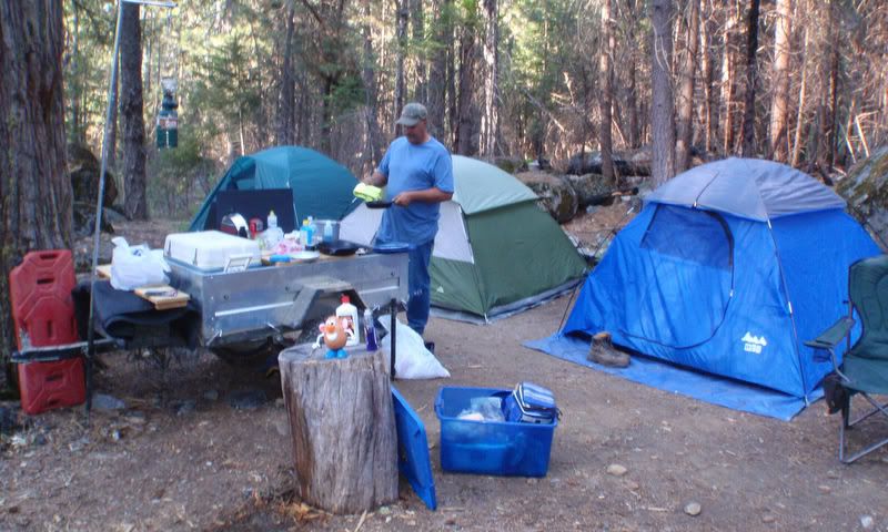
We unloaded northeast of Quincy on Mt Hough Road with camping gear on board. No freeze dried food on this trip, we decided to go all in and bring everything including a kitchen sink (a folding one, but unfortunately I forgot it at home). We ran into some nice ladies riding horses and they gave us some tips on where to find streamside campsites. A half hour later we arrived at a great looking site along Tollgate Creek:

First order of business - setup the Zodi shower. We pumped right out of the creek so no need to haul our shower water.

With our amazingly large loads of crap now dumped, fire pit constructed and hot showers ready to roll, we saddled up and headed out. Nice view of Quincy from the road to our campsite:


We zoomed up to Mt Hough to checkout the view. The best view was from the Crystal Lake overlook point (also a hang glider launch) that is just below the lookout:


Here is Flyin Boy standing on the hang glider launch and looking down at the lake. This launch is only used early in the morning when there is no wind, since the prevailing wind blows from behind. With no wind, you take about four steps and plunge over the edge of the cliff before the glider has enough airspeed to actually fly. If things work out well, gravity takes over, you quickly pick up flying speed, and fly away over the lake and out into Indian Valley. If things don't work out well... well, let's not go there.

There is a 4x4 road down to the lake. The water really is crystal clear:

Looking back across the lake at the overlook and hang glider launch above:


Two forest service people drove down to the lake while we were there. They told us that a hang glider pilot died this year. RIP fellow pilot.
My ride-to-Oregon route goes through this area so we rode down to Taylorsville (a gas stop for that future ride) just to make sure it is doable. The China Grade road hits pavement on the outskirts of town:

We headed back to camp for hot showers and dinner. Steaks, potatoes, Black Forest Cobbler and margaritas were on the menu:


At around dusk we heard a rumble, looked up, and two big fire bomber planes popped over the edge of the canyon. Our guess is that the person manning Mt Hough Lookout must have seen our fairly dense campfire smoke, thought it was a forest fire, and called these guys in. I waved at the bombers and they veered off in another direction without dropping their payloads. Dang, the grizzlies were real dirty and a load of borate would have cleaned them up in a jiffy!
The next morning we decided to see where our campsite road (25N73) ended up. It ends here, a radio tower site up on Indian Falls Ridge with an impressive 360 degree view:

Looking west:

Indian Valley down below us:


Lake Almanor and Mt. Lassen in the distance (NNW):

We rode back out to Mt Hough Road, headed for the higher country and started on our primary mission of the day: see if we can find a trail up onto Grizzly Peak. Flyin Boy was in the lead and we started up a nice smooth road that gradually got narrower, rougher and steeper. It finally got to the point when turning around would be very-very tough and I was praying that Flyin Boy would recognize this and do the right thing. He did, he kept the GAS ON until we popped out on top. Victory!:


Indian Valley:

Genesee Valley, the trail comes up to the right of the tree on the right edge (rats, forgot to take a picture of it):

Our next stop was lunch at Brady's Camp Campground and then up to Argentine Rock Lookout (abandoned). More outstanding views:


Note the firm grip on the handrail. When not hooked into a hang glider I'm scared of heights!

Time to head back to camp and my map showed that we could make a nice loop out of the ride instead of having to backtrack. Things were going as expected until the nice road turned into an epic-licious and rarely used jeep trail running right up the side of Lower Taylor. Gas on baby, gas on!:

We popped out on top, continued on per my map, but ran into this gate:

How odd, the "Keep Out" signs were on the OTHER side of the gate and we hadn't seen a single sign on the way there! We were locked IN and not out:

Whoever built the gate knew what they were doing. There was no way around, no way under, they even have a pit-of-death awaiting any poor suckers who try to ride over the berm and log:


We briefly considered building a ramp out of the logging residue and doing some Evel Knievel action OVER the gate... [-o<

...but decided that we both sucked too much as riders to pull that off safely.
After riding around a bit to try and find another way out (fail - there aren't any), back down the jeep trail we went and again confirmed that there were NO SIGNS, GATES OR ANY INDICATION OF PRIVATE PROPERTY along that route. We circumnavigated Little Taylor on real roads and found the road leading to the gate from the other side. Criminey, if you can afford to put up this many signs you'd think you could just hang ONE sign on the other way in:


The ride back to camp was uneventful. We grabbed hot showers then cooked dinner: spaghetti, garlic bread sticks, corn on the cob, more margaritas and a vanilla apple cobbler for dessert:

Two successful riding days in the bag. I'll post later about day 3.
We unloaded northeast of Quincy on Mt Hough Road with camping gear on board. No freeze dried food on this trip, we decided to go all in and bring everything including a kitchen sink (a folding one, but unfortunately I forgot it at home). We ran into some nice ladies riding horses and they gave us some tips on where to find streamside campsites. A half hour later we arrived at a great looking site along Tollgate Creek:
First order of business - setup the Zodi shower. We pumped right out of the creek so no need to haul our shower water.
With our amazingly large loads of crap now dumped, fire pit constructed and hot showers ready to roll, we saddled up and headed out. Nice view of Quincy from the road to our campsite:
We zoomed up to Mt Hough to checkout the view. The best view was from the Crystal Lake overlook point (also a hang glider launch) that is just below the lookout:
Here is Flyin Boy standing on the hang glider launch and looking down at the lake. This launch is only used early in the morning when there is no wind, since the prevailing wind blows from behind. With no wind, you take about four steps and plunge over the edge of the cliff before the glider has enough airspeed to actually fly. If things work out well, gravity takes over, you quickly pick up flying speed, and fly away over the lake and out into Indian Valley. If things don't work out well... well, let's not go there.
There is a 4x4 road down to the lake. The water really is crystal clear:
Looking back across the lake at the overlook and hang glider launch above:
Two forest service people drove down to the lake while we were there. They told us that a hang glider pilot died this year. RIP fellow pilot.
My ride-to-Oregon route goes through this area so we rode down to Taylorsville (a gas stop for that future ride) just to make sure it is doable. The China Grade road hits pavement on the outskirts of town:
We headed back to camp for hot showers and dinner. Steaks, potatoes, Black Forest Cobbler and margaritas were on the menu:
At around dusk we heard a rumble, looked up, and two big fire bomber planes popped over the edge of the canyon. Our guess is that the person manning Mt Hough Lookout must have seen our fairly dense campfire smoke, thought it was a forest fire, and called these guys in. I waved at the bombers and they veered off in another direction without dropping their payloads. Dang, the grizzlies were real dirty and a load of borate would have cleaned them up in a jiffy!
The next morning we decided to see where our campsite road (25N73) ended up. It ends here, a radio tower site up on Indian Falls Ridge with an impressive 360 degree view:
Looking west:
Indian Valley down below us:
Lake Almanor and Mt. Lassen in the distance (NNW):
We rode back out to Mt Hough Road, headed for the higher country and started on our primary mission of the day: see if we can find a trail up onto Grizzly Peak. Flyin Boy was in the lead and we started up a nice smooth road that gradually got narrower, rougher and steeper. It finally got to the point when turning around would be very-very tough and I was praying that Flyin Boy would recognize this and do the right thing. He did, he kept the GAS ON until we popped out on top. Victory!:
Indian Valley:
Genesee Valley, the trail comes up to the right of the tree on the right edge (rats, forgot to take a picture of it):
Our next stop was lunch at Brady's Camp Campground and then up to Argentine Rock Lookout (abandoned). More outstanding views:
Note the firm grip on the handrail. When not hooked into a hang glider I'm scared of heights!
Time to head back to camp and my map showed that we could make a nice loop out of the ride instead of having to backtrack. Things were going as expected until the nice road turned into an epic-licious and rarely used jeep trail running right up the side of Lower Taylor. Gas on baby, gas on!:
We popped out on top, continued on per my map, but ran into this gate:
How odd, the "Keep Out" signs were on the OTHER side of the gate and we hadn't seen a single sign on the way there! We were locked IN and not out:
Whoever built the gate knew what they were doing. There was no way around, no way under, they even have a pit-of-death awaiting any poor suckers who try to ride over the berm and log:
We briefly considered building a ramp out of the logging residue and doing some Evel Knievel action OVER the gate... [-o<
...but decided that we both sucked too much as riders to pull that off safely.
After riding around a bit to try and find another way out (fail - there aren't any), back down the jeep trail we went and again confirmed that there were NO SIGNS, GATES OR ANY INDICATION OF PRIVATE PROPERTY along that route. We circumnavigated Little Taylor on real roads and found the road leading to the gate from the other side. Criminey, if you can afford to put up this many signs you'd think you could just hang ONE sign on the other way in:
The ride back to camp was uneventful. We grabbed hot showers then cooked dinner: spaghetti, garlic bread sticks, corn on the cob, more margaritas and a vanilla apple cobbler for dessert:
Two successful riding days in the bag. I'll post later about day 3.