DeLorme PN-40 Mapping GPS Review

What did you buy? Spill it! Was it good? Suck?

Moderator: hemingray

User avatar
ACLakey
Knows UPS driver on a 1st name basis
Posts: 457
Joined: Fri Apr 22, 2005 12:38 pm
Location: Klamath Falls, Or
Contact:

DeLorme PN-40 Mapping GPS Review

Postby ACLakey » Thu Jun 11, 2009 1:25 pm

I have been looking for a replacement for my good old Garmin Emap that has served me very well over the years. In that time I have had several Garmin Etrex series, a Magellan Sportrak and a newer Garmin 60CSx. All of them have been good units but I still feel something was missing. I recently purchased a DeLorme Earthmate PN-40 and so far I am extremely impressed with this unit.

Image

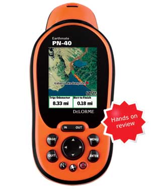
I purchased the unit from Walmart.com who has them on sale for $245 at the time of the purchase.

http://www.walmart.com/catalog/product. ... d=10759794

Image

The unit comes with the DeLorme Topo software, a 1gb memory card, a package of Energizer batteries, and a lanyard. The picture shows the unit coming with Topo 7 but mine came with the new Topo 8 software package and the most recent firmware version 2.5! I looked at the information on the unit and it had a manufacture date less than a month old, how new is that. :)

Geocaching

The PN-40 has paperless geocaching capability which is a HUGE benefit for those like myself who are hopelessly addicted. Below are some screen shots from another website showing the notes and other information that can be loaded form geocaching.com in the form of a GPX file. The notes and hints load the past five logs from the website and can be accessed while looking at the cache or while navigating. Very cool!! Below are some screen shots off of another website.

ImageImage
ImageImage

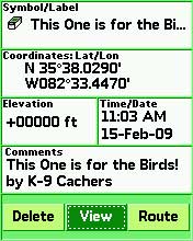
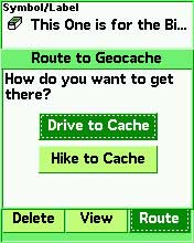
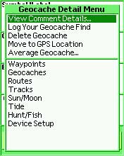
Once you have found a cache it brings up another screen so you can add notes and look for other caches. Another great benefit of this unit is when you return to your geocaching page you can upload your field notes and log your visits without having to visit each cache description....very nice.

Mapping

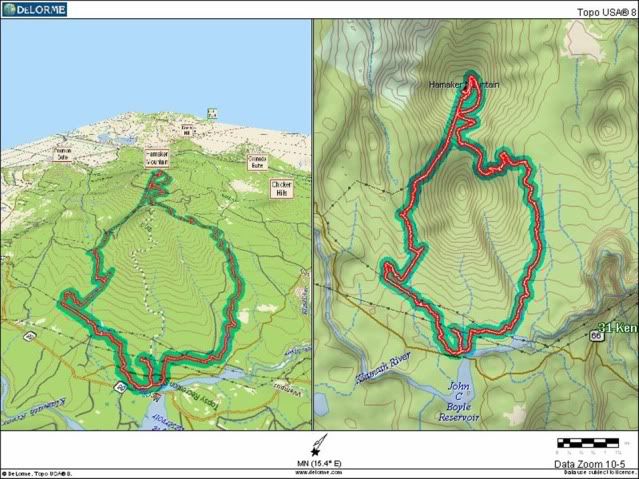
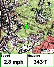
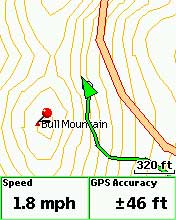
I use my hand held unit quite a bit attached to my ATV or in my hand while hunting. I found this unit maintained lock very well. On my last ride I had my old Emap on the handle bars and sense my Ram mount had not arrived yet the PN-40 was wrapped in a rag and placed into a fender bag. The PN-40 never lost lock and acturally tracked better than the unit on the bars...Very impressive. I have not seen an issue with loosing satellite lock and would compare it to the Garmin 60CSx that I have used in the past. Here is a route taken from our past ride.

Image

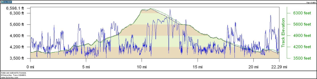
Here is the associated profile, the blue line was my speed

Image

I am liking this unit more and more.

Other Features

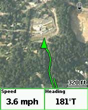
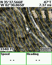
Where the PN-40 really shines over other units in my opinion is the ability to download aerial images, quad maps, NOAA nautical charts and Sat images! You read that right you can overlay the basemap over an aerial image and still see your location. If you have other maps loaded you can toggle back and forth as to what background you would like to see. This is very impressive and with the capability of handling a 32gb memory card you have one powerful tool. Below are a few screen shots off another site.

ImageImage
ImageImage
ImageImage

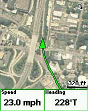
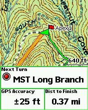
This unit will also do turn by turn directions although it does not talk to you like others out there it does beep to let you know when to take an action. I did notice that if you clicked on a point of interest you could get the address and phone numbers to the locations. I know the 60csx has this function and some other handheld units might that I am not familiar with.

Conclusion

All in all I am very pleased with this unit and if I would do it again I would choose the PN-40 in a heart beat. It does not have the fancy features like touchscreen like the Oregon does but feature for feature, dollar for dollar this unit can not be beat.

DeLorme PN-40 pros
  • Aerial imagery, USGS topo maps
    Detailed hard-copy owners manual included
    Topo USA included in purchase
    Triaxial electronic compass
    Fast redraws
    Paperless geocaching
    Good visibility in various daylight conditions
    Excellent support forum
DeLorme PN-40 cons
  • Small screen
    Unintuitive software (Topo USA)
Below is a link to a much more detailed review which I used the screen shots from.

http://gpstracklog.com/2009/02/delorme- ... eview.html

tinhunter
Just opened an account at Cabelas
Posts: 28
Joined: Sun Oct 21, 2007 9:49 pm
Location: manteca, ca

Postby tinhunter » Thu Jun 11, 2009 6:53 pm

I have this same unit and I agree that it is probably the best unit on the market right now. If you have Delorme's Xmap program you can have any type of map scanned and Xmap will encode it so the PN-40 can read it. They are also working on a beta version of some firmware that allows the PN-40 to be able to read all of the Navionic hot maps for lakes and marine areas. Most of the time my accuracy reading is around +-9' and I have gotten as good as +-6'.
Another drawback to the Topo program is the routing options. When making a route it will sometimes have you make unnecessary turns. When I was towing my trailer it tried to lead me down a road that crossed a creek just to save me a mile or two. I now have to go through the route before I upload it to the GPS to make sure it isn't making me take any unnecessary turns. Other than a few quirks with the program I couldn't be happier with the unit.

User avatar
ACLakey
Knows UPS driver on a 1st name basis
Posts: 457
Joined: Fri Apr 22, 2005 12:38 pm
Location: Klamath Falls, Or
Contact:

Postby ACLakey » Thu Jun 11, 2009 7:32 pm

Do you have the Xmap software? I have some high quality sid files of the city and entire county we did for work a few years ago that I would like to convert and use in the PN-40. We are also looking to get the ESRI module to see if it will allow us to download parts of our GIS system. That would be great for maintenance crews to locate infrastructure in all weather conditions quickly.

tinhunter
Just opened an account at Cabelas
Posts: 28
Joined: Sun Oct 21, 2007 9:49 pm
Location: manteca, ca

Postby tinhunter » Fri Jun 12, 2009 10:15 am

I don't have it. I have been waiting for the price to drop some before I buy it. I want to be able to scan forest service maps so that I can have all of the roads and trails on my PN-40 when I am out.

User avatar
RobG
Is tracking a shipment right now
Posts: 223
Joined: Thu Mar 31, 2005 1:40 pm
Location: San Jose, CA
Contact:

Postby RobG » Sun Aug 23, 2009 9:57 pm

Just found this thread...

I have the PN-40 also. I got it back in December when they first came out... I sprung for the extra $$ and got the PN-40 SE with 8 gig of internal RAM, and added a 32 gig card to it, for 40 gig total.

The power of this thing is unreal... a dual-core CPU in a GPS!! The display, while very small, is really nice looking and easy to read. I run it off of 12v on the quad so I can keep the backlight on. Mine came with the "travel kit" that included a rechargeable lithium-ion battery. It'll just barely last a day of snowmobiling in the cold. I don't have 12v on my sled (2-strokes are AC) so it's good to have the battery last.

I really dislike Delorme's Topo 7/8 (I just upgraded to v8) program. The UI is one of the worst I've seen. I spend most of my time in Maptech's Terrain Navigator... er... MyTopo now owns it. I'm bugging them for a Delorme driver so I don't have to download my tracklogs into Topo 8 first, export as a GPX, then convert it to TXF.

But all in all, it's a great unit!

Rob
'09 Polaris Sportsman XP 850 EPS
'08 Polaris Outlaw 525 S
'08 Polaris Outlaw 525 IRS
'02 Yamaha Grizzly 660
'05 Arctic Cat M7 153

'05 Dodge RAM 3500 QC 4x4 6sp
'06 Keystone Raptor 3814SS 5th Wheel Toyhauler

The Modfather
Is tracking a shipment right now
Posts: 198
Joined: Mon Mar 19, 2007 5:02 pm
Location: Cameron Park, CA

Postby The Modfather » Wed Oct 14, 2009 9:37 pm

I picked up a PN-30 about a week ago. I'm really on the fence for this unit. Well, I should clarify - The unit itself is pretty cool, but the Topo 8 software that came with it sux nuts. Not very straight forward, and being a GPS n00b, I have spend a LOT of time learning what they call things, and how they work. I'm still lost but I'm hoping it gets easier as I become more familiar with the unit.
[img]http://fusionlangaming.com/random.jpg[/img]

User avatar
RobG
Is tracking a shipment right now
Posts: 223
Joined: Thu Mar 31, 2005 1:40 pm
Location: San Jose, CA
Contact:

Postby RobG » Wed Oct 14, 2009 9:59 pm

Yes, the DeLorme Topo 8 software is awful from a UI standpoint. I've told them this several times on their own forum. I'm a computer geek and programmer and have been using GPSes for ten years and I find it baffling more often than not.

If you post over on the DeLorme forum though, they will usually have an answer to your questions within an hour or two. They're very responsive.

Rob
'09 Polaris Sportsman XP 850 EPS
'08 Polaris Outlaw 525 S
'08 Polaris Outlaw 525 IRS
'02 Yamaha Grizzly 660
'05 Arctic Cat M7 153

'05 Dodge RAM 3500 QC 4x4 6sp
'06 Keystone Raptor 3814SS 5th Wheel Toyhauler

The Modfather
Is tracking a shipment right now
Posts: 198
Joined: Mon Mar 19, 2007 5:02 pm
Location: Cameron Park, CA

Postby The Modfather » Sat Oct 17, 2009 5:21 pm

So I'm not sure exactly how to do everything I need to do and the manual is quite a bit overwhelming so I'm comin here in hopes that those more familiar with the device and topo software can point me in the right direction. Truth be told, I don't even know what I *need* the unit to do.

Basically I trail ride. Maybe it'd be best to give a little info on what I do and maybe what I'd like to be able to do w/ the unit. I would like to be able to see the trails I rode, maybe take the "paths" that I've taken (without having to stop, pull out the unit, and 'mark' waypoints every so often). Once that data is input into the device, I would like to be able to extract it and 'overlay' it onto a satellite image (like google earth or soemthing?) in hopes of finding other nearby trails or see what we missed.

Another thing I'd like to be able to do would be to look in GE, or a similar app, plot a course, and watch the GPS as I ride. Ideally, I would like to be able to combine the 2 features, in case I see a side trail that looks interesting or whatever. I'm not sure this is even an option.

Finally, I would like to be able to 'mark' my starting point, so in the event I get totally screwy, I could use the GPS as a kind of homing beacon to be able to tell me "Hey numb nuts - the truck is 14 miles over there - as the crow flies!"

Are there any other features that would benefit me that I haven't discussed? I know it's a lot to ask - especially on an intarwebnets forum - but just looking for some kind of guidance.

Oh and if there is a better app than Topo 8 that is compatible w/ the PN30 - PLEASE let me know the name of it! That is to say, I'm not a total incompetent - nor am I technologically lacking (I'm a server admin) but seriously, could they have at least chosen someone with a personality to program that app?!

Thanks in advance guys!
[img]http://fusionlangaming.com/random.jpg[/img]

User avatar
RobG
Is tracking a shipment right now
Posts: 223
Joined: Thu Mar 31, 2005 1:40 pm
Location: San Jose, CA
Contact:

Postby RobG » Sat Oct 17, 2009 8:56 pm

First, unfortunately, there is no other app than Topo 8. Sorry. I wish there was.

Second, you will want some sort of GPS file converter. Google "GPS Babel" and download it. It'll let you convert the GPX files generated by Topo 8 into the KML or KMZ files for Google Earth and vice versa.

You can do pretty much everything you asked about doing.

I don't know the precise way to do it in Topo 8 (yet) but basically you will want to look at the maps of where you want to ride... maybe spend the $30 for the annual map data membership so you can download USGS 7.5' maps and overlay them in Topo 8 AND even transfer them into your PN30 on a memory card.

So yeah... you'll look at the maps, and you will create a Route. I'm going to have to play with Topo 8 more later and find the exact steps for you. But create a route and trasnfer it to the PN30. This is one thing that Topo 8 does extremely well -- data exchange between the GPS and the program itself. But you can also save the Route out as a GPX file if you want, convert it to GE format, and then view the proposed route there.

Whenever I ride, I always mark a waypoint wherever I park. Just hit the little "Thumbtack" button on the PN30 to do that. The PN30/40 do a really nice job of routing you places using the built-in maps. When I was at the Miyagi ride, I was out riding north of Jackson Meadows the morning we were heading to the hotel. I searched in the PN40's POI database (Points of Interest) and found the Washington Hotel, and hit Route. It created a turn by turn route for me to follow there. It was slick!

When you're back from your ride... load up Topo 8, plug in the PN30, and you can transfer the track log into Topo 8. Then save it out as GPX, convert to KML, and view in GE. Or in Topo 8 too. I do this for all my rides.

I can tell you this much... Topo 8 calls the Routes and Tracks area the "Draw Layer" or similar. It makes no sense to me, but it does. This might help you get started until I figure more of it out and can post it.

Rob
'09 Polaris Sportsman XP 850 EPS
'08 Polaris Outlaw 525 S
'08 Polaris Outlaw 525 IRS
'02 Yamaha Grizzly 660
'05 Arctic Cat M7 153

'05 Dodge RAM 3500 QC 4x4 6sp
'06 Keystone Raptor 3814SS 5th Wheel Toyhauler

The Modfather
Is tracking a shipment right now
Posts: 198
Joined: Mon Mar 19, 2007 5:02 pm
Location: Cameron Park, CA

Postby The Modfather » Sat Oct 17, 2009 11:14 pm

Thanks for the awesome help Rob!

It's quite overwhelming [read: frustrating] when companies decide to "think" outside the box and redefine commonly used terms.

I'm excited to try out the new bells and whistles - hoping to be as comfortable with the device and software as I am with operating systems :mrgreen:
[img]http://fusionlangaming.com/random.jpg[/img]

User avatar
hemingray
Certified: OBSESSED
Posts: 1898
Joined: Mon Mar 12, 2007 2:24 pm
Location: Auburn, CA

Postby hemingray » Sun Oct 18, 2009 10:12 am

Google Earth will open .gpx files directly, you just have to change the filetype in the open dialog. Too bad they don't do it the other way around!

I sometimes like to create a waypoint in GE and just enter the coordinates by hand into ExpertGPS. Thanks for the tip, Rob, about GPS Babel! That will make life easier.
Wherever I go, there I am

Paynes Creek 2016!

~~~~~~~~~~~~~~~~~~
16 Yamaha Wolverine R-Spec EPS SE
09 Yamaha Grizzly 700 FI 4x4 EPS


Who is online

Users browsing this forum: No registered users and 26 guests